MONTHLY RESERVOIR REPORT for April 1st
by Maven's Notebook
4-3-2023
Written for Maven’s Notebook by hydrologist Robert Shibatani
It has indeed been a March full of madness; and for many reasons other than the usual collegiate festivities.
The month has seen a seemingly continual procession of atmospheric rivers battering the State with conditions that have led to levee breaches, localized flooding, land/mudslides, widespread emergency declarations, and mandatory evacuations. Thankfully, the effects have been largely regionalized compared to previous years, as not all areas of the State have had to endure this year’s weather-related calamities. The State Capitol region, for example, has remained relatively unscathed… touch wood.
While the first day of April typically holds significance among many in the California water world, it is also a convenient point from which to assess hydrologic conditions as it is now, that the flood season comes to an official end and the annual spring freshet emerges. This year too, there is the added benefit (or challenge, depending on one’s perspective) of record-breaking snow accumulations across the Sierras, particularly, in the southern Sierras. Depending on how water managers choose to operate their varied systems this spring, the benefits to water supply and/or the risks to enhanced flood risks will be determined.
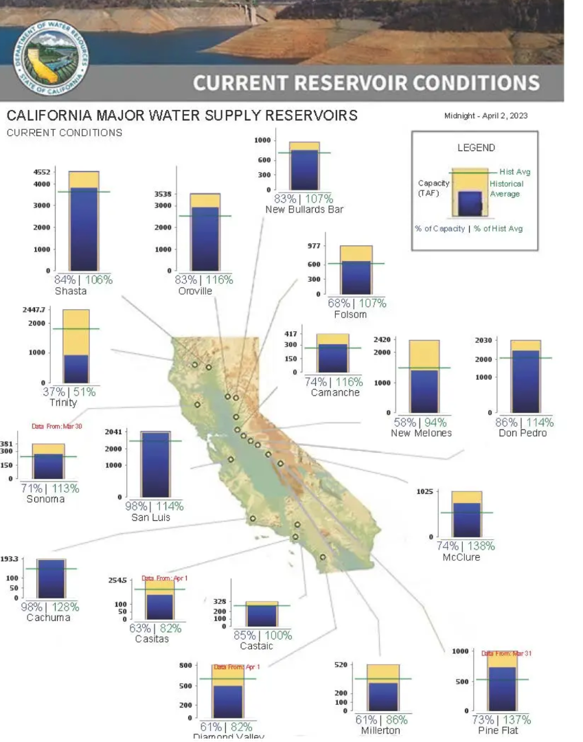
Over this past month, hydrology has allowed the large reservoirs to continue filling unabated. The combination of atmospheric river driven rainfall, saturated conditions from earlier storms, and a robust snowpack has provided a continual water source for this rapid reservoir refilling. Over the month through yesterday, Shasta, Trinity, New Melones, and Oroville reservoirs gained 997,800, 109,300, 288,400, and 340,000 acre-feet (AF), respectively.
Smaller, under-capacity reservoirs, however, have encountered particular challenges during this year’s same hydroclimatic conditions as they struggle to maintain reservoir empty space (e.g., conservation pool), a requirement made that much more difficult with a record-breaking snow accumulation (and its pending melt), and, at the same time, for operators to remain sensitive to the need to refill reservoirs following sequential years of drought.
The classic example is Folsom Reservoir. While the term weather whiplash is well known, Folsom Reservoir demonstrates a different version of this backlash, namely, operational whiplash. The reservoir, over the month, has undergone 5 cycles of deliberate operational “filling” and “spilling”, where operational management decisions have prompted both storage accretion and depletion, sometimes flip-flopping between the two every 3-4 days. A small multi-purpose reservoir must, as we often call it, “ride the curve”, that is, the reservoir-specific flood encroachment curve during the flood season. Maintaining that delicate balance within the reservoir between active storage and empty space during the flood season is an ongoing challenge, especially if the source area catchments are continually generating high runoff volumes.
Spilling has occurred from Folsom Reservoir over 19-days this past month and totaled over 355,000 AF, just for March. Combine that with the 188,000 AF “spilled” during the New Year’s storms earlier this winter and total “spillage” from Folsom for the year-to-date exceeds 543,000 AF. Other CVP reservoirs have refrained from “spilling”.
In the case of Folsom Reservoir, these storage implications, while subtle to many, are particularly noteworthy this year as operators struggle to take advantage of this year’s robust precipitation accumulations while maintaining compliance with long-standing reservoir encroachment rules. As of yesterday, Folsom’s storage was 665,000 AF, and rising rapidly, ostensibly leaving only 312,000 AF of “empty space”.
The one positive development? Recent allocation declarations by the U.S. Bureau of Reclamation for CVP contractors both north and south of the delta have improved markedly from earlier allocation forecasts.
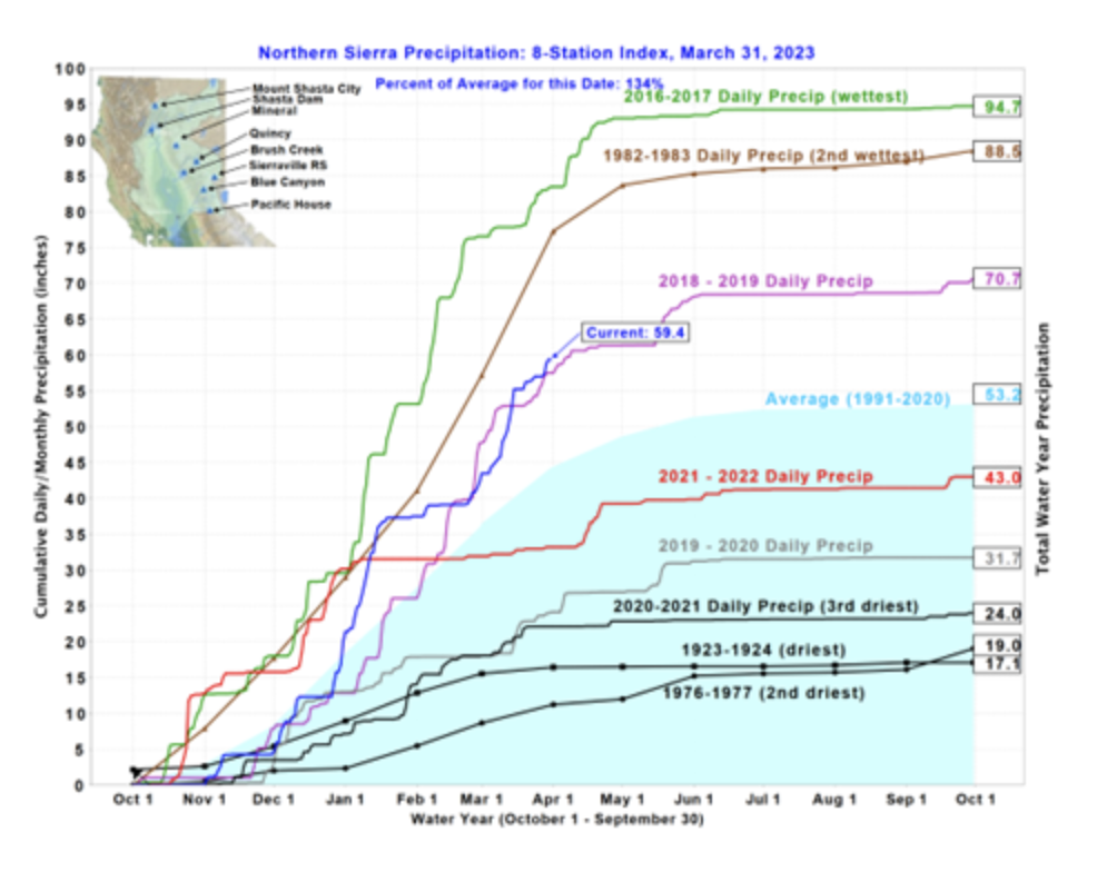
Figure 1 below shows the current status of the Northern Sierra Precipitation: 8-Station Index for March 31, 2023. It reveals that the current index stands as 59.4 inches of precipitation, representing 134% of average for this date.
Still, while this year’s weather leaves the impression that this is a record wet-year, precipitation totals are well below those of several past years. In fact, some of these past years were quite recent and significantly exceeded or were similar to this year’s totals (e.g., WY 2016-17, 2018-19, and 1982-83). Precipitation indices in the central and southern Sierra Nevada show similar results with that of the Northern Sierra Precipitation: 8-Station Index. The San Joaquin Precipitation: 5-Station Index is 61.1 inches, representing 185% of average for this date (and not far off the record 1982-83 and 2016-17 WYs). The Tulare Basin Precipitation: 6-Station Index stands at 50.5 inches or 215% of average. Here, in the Tulare Basin, accumulated precipitation for this index is only 5.8 inches shy of the all-time record of 56.3 inches set during the 1968-69 WY.
By far, however, the biggest weather news for the State has been this year’s record-shattering snow accumulation.
Statewide, the SWE currently stands at 60.8 inches. This represents about 235% of the average for this date. The southern Sierra SWE is 61.9 inches, or 298% of average. In the northern Sierra, the SWE is 56.8 inches (equivalent to 190% of the average for this date) and 62.2 inches in the central Sierra, or 233% of the average for this date.
As we noted last month, snow contributions to the overall water supply outlook for 2023, while seemingly robust, will depend largely on how the State’s various snowpacks ablate (e.g., sublimate and melt) over the next 2-months and whether additional precipitation events remain on the horizon. The intensity and rapidity of daily melt will determine the urgency endured by reservoir operators as they facilitate peak-melt releases from storage without unduly over-stressing downstream river channels.
As the Statewide deep snowpack continues to ripen, the worst-case scenario from either a flood control or water supply perspective would be for a windy, warm/hot period to emerge, interrupted by a slow-moving warm tropical “triggering” storm front that could linger over the Sierras. Such conditions would create dire circumstances for reservoir operations
Photos
Website Hosting and Design provided by TECK.net